Home » Flood mitigation » Flood mitigation information » Floodplains and floods
Floodplains and floods
What is a floodplain?
Floodplains are dynamic environments. They are also a resource of immense value and rich natural environments supporting a large biodiversity. Since European settlement there have been immense changes to the floodplain environment with clearing of vegetation and changes to the creeks and natural drainage systems.
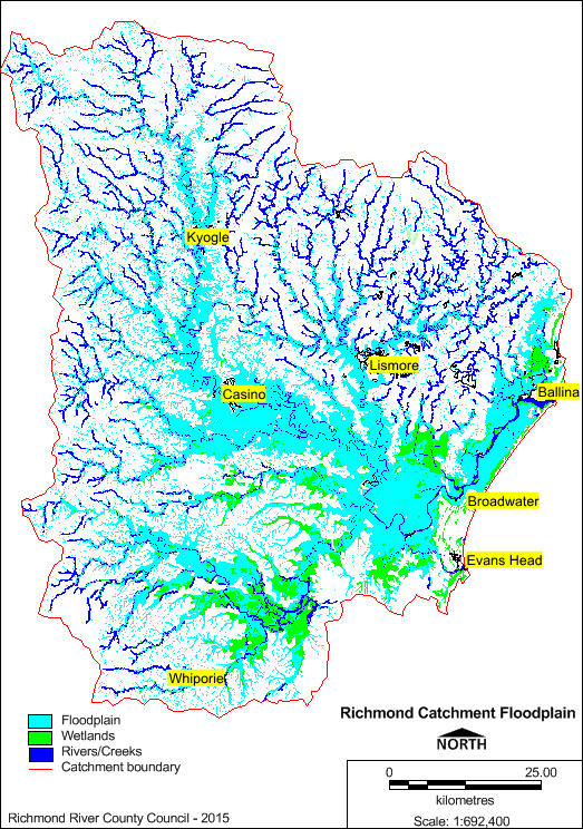
The Richmond River floodplain is the largest coastal floodplain on the NSW coast, covering 1,000 square kilometres with a waterway area of 19 square kilometres. The tidal limit is 110 kilometres, extending to Casino on the Richmond River and Boat Harbour at Lismore on the Wilson River.
Most of our cities and towns are located on the floodplain. This is an historical outcome as most of the travel and trade in the earlier times was by boat. Some of the settlements include Lismore, Casino, Coraki, Woodburn, Broadwater, Wardell and Ballina.
Floods
Floods are a naturally reoccurring event in the Richmond catchment, with the earliest recorded flood events dating back to 1857. Seven major floods have been recorded since 1857, with the two largest occurring in 1954 and 1974.
Following the 1954 disaster, state and local governments and the local community resolved to address the flood problems through mitigation. Council conducted infrastructure works from 1960 to the late 1980s to reduce flood impacts and to remove flood water more rapidly. Levees, flood channels and floodgates were installed to not only protect settlements, but also to open up areas for agriculture. Flood mitigation continues using the methods noted above, with concentrated works targeted at high population centers. Councils and state government now use planning tools and regulation to prevent inappropriate development on the floodplain that will limit the populace from the dangers associated with flooding.
The NSW Government’s ‘Flood Prone Land Policy’ requires flood studies and management plans to be developed incorporating sustainable strategies for human occupation and utilisation on the floodplain. In the Richmond catchment, flood risk management studies have been carried out for Ballina, Lismore, Casino and the mid Richmond. These studies identify flood flows and flood extent and height for 1:20, 1:50, 1:100, 1:500 year and PMF events. These studies also identify works that can be implemented to reduce flood problems. In Lismore, the Lismore Levee was constructed as an action of mitigation provided as a recommendation of the flood study.
There are many homes and businesses on the floodplain that rely on the protection of levees and floodgates. In some areas, local councils and state and federal governments fund a scheme used to buy houses in high-risk areas. This scheme, known as Voluntary House Purchase, began after the disastrous flood of 1954. The scheme enters into an agreement where houses are purchased from people who wish to sell. The house is then removed from the site and the remaining house block is left as open parkland, effectively removing the family from flood risk, while creating an open public space.
Information on floodplains and the flood prone land policy can be accessed from the links below.
The State Government’s Floodplain Development Manual and other information: https://www.environment.nsw.gov.au/topics/water/floodplains/floodplain-manual
Flood warnings are issued by the NSW Bureau of Meteorology (BoM) and there is an extensive amount of information provided by the BoM on Northern Rivers rainfall and river heights and Northern Rivers forecasts.
Flood mapping and elevation
The map of the Richmond catchment floodplain (23.4mb) is provided in a PDF format, with interactive ‘clickable’ layers that may be removed or added and zoomed into via the zoom function. The layers show:
- 1:100 year flood velocity and flow direction
- 1:100 year flood mapping
- cadastral (property boundaries, rivers, roads), and
- digital elevation model (DEM) that shows the height of the ground surface measured in the Australian Height Datum (AHD).
The map should be used as a guide only; if accuracy is required, a local ground survey should be performed by a qualified surveyor.
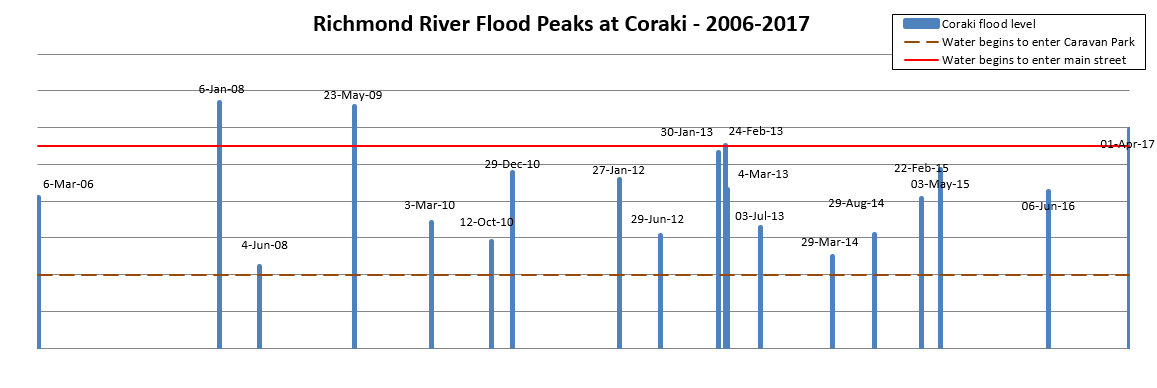
Flood graphs
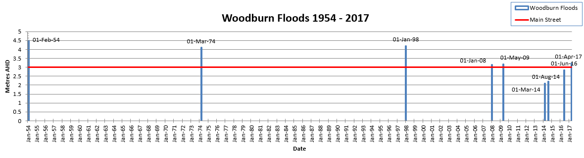
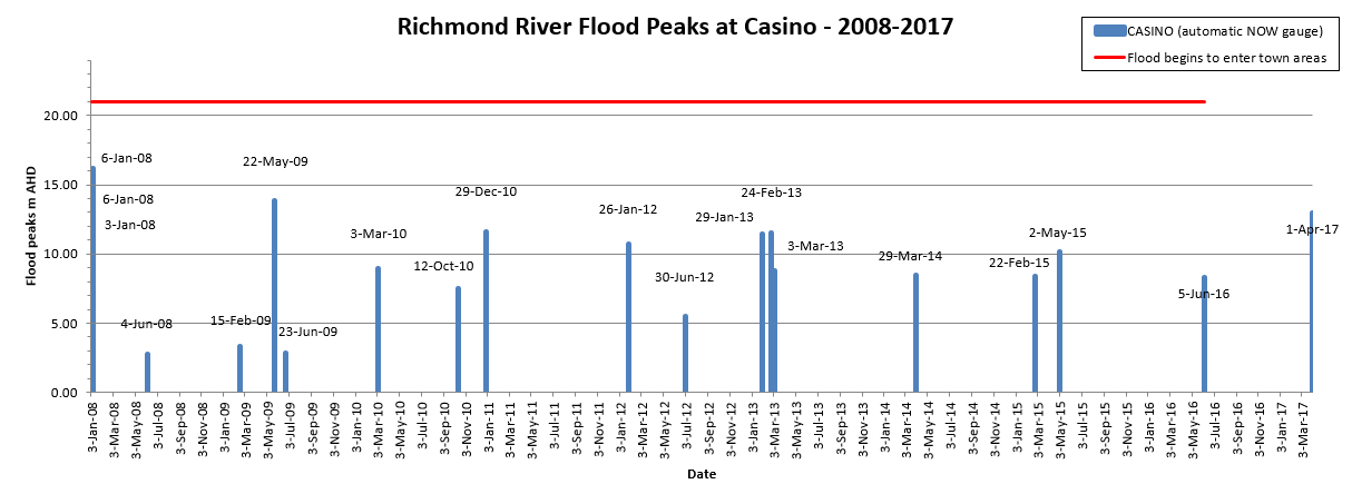
The following flood graphs show the heights of recorded floods at Lismore, Coraki, Woodburn and Casino. Lismore flood graphs show floods rated above moderate from 1921 to 2013, and all floods between 2008 and 2015. Approximate flood heights are shown where floodwaters may enter towns, however these should be taken as a guide only as all floods have different characteristics due to the range of rainfall events, and the height of flood levels can vary due to local conditions such as topography and runoff. Recent flood heights are taken from the Bureau of Metrology website and supplies the last four days of river heights, both graphed and as a table, and can be accessed at http://www.bom.gov.au/nsw/flood/northcoast.shtml
Lismore moderate to major flood peaks, 1880-2017

Lismore flood peaks, 1921-2017

Lismore floods, 1870-2017 (Lismore City Council data)
.PNG)
Wilson River flood peaks at Lismore, 2008-2017

Richmond River flood peaks at Casino, 2008-2017
Richmond River flood peaks at Coraki, 2006-2017
Woodburn floods, 1954-2017